And in Overland...
My former UMSL classmate Mary Beth Conlon is a current Ward 2 alderman and candidate for mayor.
I'm sure she would do a fine job at the helm of that community.
Election Day is Tuesday, April 4th.
Friday, March 31, 2006
Sidewalk Stories
Sidewalk Stories
After a nearly three-year wait, yesterday part of our sidewalk was replaced free of charge!
Legally, sidewalks are the responsibility of the property owner. But most people know the City of St. Louis offers a 50/50 Sidewalk Program in which the City contracts with an outside construction company (usually these days, Stika Brothers Concrete Contractors of 10703 Tesshire Dr. in the Concord Village/Affton area).
Stika rebuilds the sidewalks under an annual contract let by the City Board of Public Service (BPS). The City Streets Department, Sidewalk Manager Wally Hose sends bills to property owners for 50% of the cost.
But less well-known is that, if a tree owned and maintained by the City Forestry Division damages a section of sidewalk, then the replacement is still handled by Wally Hose via Stika, but is free of charge to the property owner.
So, it takes a long time to work through the process, but once the work gets going, it's pretty quick. They seem to have a schedule of working through certain areas of the city at a time. Last year, they redid many of the sidewalks on my father-in-law's property, even including a new curb-cut at the corner and new concrete for his driveway apron between the sidewalk and street.
Probably in May 2003 (right after we bought the place), I called my alderman to sign up for the replacement of just two squares uplifted by the roots of the city-owned tree out front.
In fall 2005, we got a letter from the Street Department, after a Forestry inspector came out and noted that, yes indeed, the tree's roots lifted up two squares of the sidewalk several inches over the years.
Then, last Friday (March 24th), the old walk was removed and a number of shallow roots too. On Tuesday or Wednesday, new forms were placed which make a "tree well" that narrows the sidewalk a little on one side, which (hopefully) will give the tree enough room to spread out.
Yesterday (March 30th) about 8:30 AM, the new concrete was poured. Once the work gets going, they're really fast! Stika gets the actual concrete from a mixer truck owned by Lemay Concrete Block Co. - which despite the name, is actually located at 7900 Reilly Ave in the City.
Soon after the pouring and floating of the new 'crete, it starting raining, so they placed plastic on top to protect it. After the rain, the Stika crew came back to make the swirly patterns on it and draw a little line to make the single pour look like it was two separate squares.
By noon, the new walk was pretty much dry. Unfortunately, I didn't guard it like I should have, so it did get a few footprints and a bicycle track on it!
**Sigh**
So after waiting three years for this, it's slightly messed up. That's not the fault of the city nor the contractor, of course. Well, at least I didn't have to pay for it.
And at least nobody tried to write their names in it either.
Wednesday, March 29, 2006
Crosstown Boogie
Crosstown Boogie
Well, yesterday's Post-Dispatch says Metro Transit next month will unveil an online trip planner feature similar to what places like Seattle, Minneapolis and L.A. have had for years.
This is long overdue, given the relative user-unfriendly nature of the online bus schedules and system map, both of which are available only in PDF.
But it got me to thinking: Is there any chance we could get a few more crosstown bus routes in the City of St. Louis?
Back in the 1980s and 90s, printed Bi-State bus schedules were color-coded (ink, not paper) based on what region of the metro area they served.
Brown = South City and County
Red = Southwest City and County
Green = Northwest City and County
Blue = North City and County
Purple = Illinois
Black = Crosstowns
Nowadays, I guess because it's cheaper, all schedules are printed in black ink. Also, some routes like the #11 Chippewa crossed over different sectors, so it wasn't really that helpful ultimately.
The following routes that are still in operation are long-time crosstowns:
#40 Broadway
#70 Grand
#42 Sarah
#18 Taylor
#95 Kingshighway
#13 Union-Garden
#90 Hampton
#16 City Limits
#47 Cross County
#66 Brentwood-Airport
#49 Lindbergh
A few crosstowns have been eliminated, including the #01 Vandeventer and #65 Woods Mill-Westport. Some have been significantly restructured, but their core service corridors remain basically the same.
Meanwhile, a few new pseudo-crosstowns have been created in recent years via strange mergers of pre-existing routes.
The #52 Clayton-South County is a combination of the former #52 Forest Park and #73 Carondelet (and a short segment of the old #20 Cherokee), which makes for quite a long L-shaped route between the two endpoints indicated. It has two branches, like the old #52, one via Oakland Avenue / Clayton Road, and the other via Clayton Avenue / Dale Avenue.
The #30 Soulard is a U-shaped combination of parts of the former #19 Saint Louis Avenue, #30 Cass, and #96 Walnut Park in the north (and segments until recently covered by the #33 Dorsett-Lackland), with parts of the #03 Morganford-Arsenal and #21 Tower Grove in the south.
The #30 runs from Rock Road MetroLink station mainly via Saint Louis Avenue, then into downtown along 13th mainly, out of downtown via 7th and past its namesake Soulard Market, and then west along Arsenal to McCausland, and finishes up via Manchester at the Brentwoood bus garage.
Also, several of the long-standing crosstowns are not really crosstowns. Sure, the #42 Sarah and #18 Taylor run north-south, but they really only serve north city and the central corridor. Both end at MetroLink; Grand and Central West End, respectively. The #13 Union-Garden makes it a little further south, to Thurman Loop near Tower Grove Park.
But the only City routes that truly span much of the city north-to-south are the #40 Broadway (which also extends into the County mostly south, but a little bit north too), #70 Grand, #95 Kingshighway, and #90 Hampton. Even the #70 is truncated oddly, sometimes, at Jefferson/Chippewa/Broadway in the south and the Water Tower in the north. But sometimes it does run a few blocks further north to Bulwer and Gano off North Broadway; and much of the time it makes it to Grand and Iron in Holly Hills. Only the #40 and #90 service both the Baden area and the Carondelet area. In fact, except when the #90 terminates at Grand and Iron (via Wilmington/Leona/Holly Hills/Morganford), the #90 and #40 intersect both north in Baden and south at Catalan Loop, the respective termini of the #90.
Further west, the #16 City Limits and #66 Brentwood-Airport (formerly the Clayton-Airport, and before that the Maplewood-Airport terminating at St Louis Marketplace) only make it a little south of Manchester. Only the #47 Cross County and #49 Lindbergh are true County crosstowns.
Of course, several of these routes will be truncated or cut up into multiple routes when Cross County MetroLink starts operating.
Cross County MetroLink, as the name suggests, will provide a very partial crosstown option. It will connect Shrewsbury to Clayton. It certainly will not go across the entire county from Sappington to Florissant as the current #47 bus does. That bus route will probably be split into three different routes.
Even the #49 Lindbergh is not as long as it used to be, but that's probably a good thing. It frequently was way behind schedule in the years I rode it, for example, from I-255 and Telegraph Road to St Louis County Library Headquarters in LAH-due. For a time in the 1980s, it was actually privatized, but that only made it worse!
Anyway, I was thinking there are some combinations of routes that would make more sense as new crosstown routes - possibly restoring some of the old crosstown streetcar corridors long eliminated.
For example, why not combine the #11 Chippewa with the #04 Natural Bridge? True, both are very long routes. But that would restore continuous crosstown service on Jefferson Avenue (with a slight detour via Market and 14th to access Civic Center MetroLink/MetroBus Center), like there used to be until the 1950s.
This would be most feasible if the #11 was truncated at the new Shrewsbury-Lansdowne-I-44 MetroLink station. The western Watson Road corridor to Crestwood and Sunset Hills could become a new Watson Shuttle route. This is similar to the change made last year on the #04, which used to run all the way to Northwest Plaza but has been truncated at North Hanley MetroLink station. The western portion is now part of the truncated and restructured #49 Lindbergh.
Or how about combining the #10 Gravois and #74 Florissant? This would sort of reinstate the old Bellefontaine streetcar route -- except that of course the southern leg of that route was what became the #73 Carondelet bus - now part of the aforementioned #52 Clayton-South County. But this would provide a continuous routing via the 1930s superhighway that is Gravois/Tucker/N 13th/Mullanphy/North Florissant (up to Palm anyway).
That one should be pretty simple since both routes already serve the Civic Center MetroBus Center downtown, and run closely parallel routes within downtown. Perhaps the #10 would need to be truncated at Gravois-Hampton Transit Center; and similarly the #74 truncated at Florissant Valley Community College. Both effectively end at those locations most of the time, anyway.
I don't know that either suggested crosstown route would be viable nor feasible. Rather than recreating old streetcar corridors, it would be more sensible to analyze north-south travel patterns to see if folks actually are transferring from a northside route to a southside route in the downtown area, and to minimize the need for such transfers.
But are these really any wackier than the current routing of the #80 Shaw-Southampton? That one makes absolutely no sense to me.
Tuesday, March 28, 2006
Some County Endorsements
Some County Endorsements
April 4th is also an election day in many St. Louis County municipalities, school districts, fire districts, and the Maplewood library district.
University City
Shelley Welsch is the progressive choice for University City mayor. She is challenging 10+ year incumbent Joe Adams, in an incredibly heated campaign with strong racial overtones.
Adams has many yard signs along the arteries; but Welsch seems to dominate in the south U City residential areas. I haven't really surveyed north U City side streets, although one could assume that Adams would have a lock up there. But maybe not.
Although I like the idea of bright red signs with large white lettering saying "Joe's For Us!", it's kind of a poor campaign strategy. Joe who? For what? My name is Joe - are you for me, too? Yes, the signs do say "Joe Adams for Mayor", but in much less visible type.
Dellwood
Up in Dellwood, "The Crossroads of North County", the Ward 1 seat is the only contested election.
There, voters should support Loretta Johnson. In a city that is now almost 60% African-American, it's certainly time to have at least one alderman who is African-American.
Monday, March 27, 2006
Joe Frank Endorses...
Joe Frank Endorses...
The April 4, 2006 municipal election is now eight days away.
I don't really expect anybody to really take my 'endorsement' of a candidate nor a proposition seriously. But it makes me feel good to publicize my views.
It should be noted that these endorsements are my opinion alone, and do not reflect upon any entity with which I am affiliated.
For St Louis Board of Education:
Peter Downs (#3)
Donna Jones (#4)
I don't always agree with what Peter Downs says, but you have to give both him and Ms. Jones credit for challenging things they feel are wrong.
Proposition EJ
For Education and Jobs:
YES
The St. Louis Community College system provides a great collection of educational and job training programs for our community in St. Louis City and County (and Pacific MO). Tuition rates have nearly doubled in the past five years, so it's not as if students aren't paying their fair share. This tax increase would help assist in expanding and upgrading facilities at all three existing campuses, as well as replacing the ridiculously tiny William J Harrison Northside Education Center with a full-fledged job training / extension center.
Charter Amendment re: Recall Petition Process
Proposition R:
NO
Restricting the recall process is bad for democracy. True, recalls can and will be used for political expediency. But it still takes a fair bit of work to get one organized and completed. While six months isn't necessarily an unreasonable standard amount of time to collect signatures, it's still a bad idea in my eyes.
Graduated Business License Fee Increase
Proposition G:
YES
I swallow hard when I say this, but it has been almost 20 years since the business license fee has been increased. At the same time, the city's general revenue budget is really hurting. For the smallest businesses, it does represent a $50 increase; for others, more money but less percentage.
We'll see what happens on April 4th.
All Shook Up
All Shook Up
Earthquakes really scare me. Admittedly, I've never been anywhere that experienced a big one, but I have to wonder if the City of St. Louis really is prepared for one of a significant magnitude.
The midwest has frequent seismic activity. Most of it is pretty small stuff that you can't even feel unless you're really close by and it's really close to the surface. As recently as November 22, 2005, there was an 2.5 tremor with an epicenter at approximately N. 40th St. and Waverly Ave. in the Lansdowne neighborhood of East St. Louis.
According to the 'earthquakes' layer on Google Earth, a 3.0 magnitude shaker occurred in St Marcus Commemorative Park off Gravois in South St. Louis, on September 20, 1978. That might be the only one with an epicenter inside the city limits in recent memory.
SLU reports on a bunch of historical quakes felt in St. Louis. I think I recall feeling the one on February 5, 1994, although its epicenter was near Cape Girardeau.
Our historic brick housing stock with rubble stone foundations is wonderful, but also potentially dangerous in a 'quake. And the cavey Karst topography in parts of the region doesn't help matters.
If St. Louis does experience a severe earthquake, the aftermath will be the biggest concern. We managed to cope reasonably well, in some ways, after the flood of 1993.
But its arrival was long anticipated, and its effects were concentrated in certaiin areas of the region. The flood plains along the Missouri, Mississippi, River des Peres, and a few other tributaries were damaged the most. Some other areas did experience sewer backups. Concrete, immediate attempts to prevent the damage were made, like sandbagging and shoring up levees.
A significant earthquake would have widespread impacts. I know MODOT has spent years and millions of dollars to retrofit Highway 40 in downtown to prevent another tragedy like what happened on the Nimitz Freeway in Oakland on October 17, 1989.
Apparently, I-44, I-70 and Route 100 (Manchester, in the County anyway) are designated as Earthquake Emergency Highway Routes. Also, any new bridge or overpass built since 1990 by MODOT should meet seismic design standards.
But that still seems to leave a number of places vulnerable. For example, what about the double-decked stretch of Highway 40 from about Forest Park Parkway/Compton/Market to west of Vandeventer? That section spans Grand Boulevard, a major north-south thoroughfare. If it isn't retrofitted, that seems like a huge potential problem. Likewise, although the Grand viaduct across MetroLink and the railyards just south of there is scheduled for reconstruction soon, Grand itself passes above Eastbound I-64 and below Westbound I-64 on a 1940s structure built as part of the Market Street bypass.
I know some work has been ongoing in that area; and the Compton and Market bridges are scheduled for replacement this year. (That'll be a huge traffic mess, no doubt, as Market, Compton, and Forest Park traffic will need to detour via Olive, Jefferson, and Chouteau.)
Then there's the bridges and overpasses maintained by the City's BPS. They've been more aggressive lately about planning and scheduling bridge replacements; for example, Lansdowne over River des Peres was finished pretty fast, and now the small Arsenal bridge next to Schnucks as well as the South Broadway bridge over River des Peres are being replaced currently. Still, there are a number of bridges built during the 1970s and 1980s - for example, the Vandeventer/Tower Grove viaduct spanning the railyards - that I suspect are not seismic-compliant.
Then there's that awful South Kingshighway viaduct over the UP track between Southwest and Shaw. It really needs to be replaced soon, although I realize it would be a real traffic nightmare to detour to Vandeventer. At least Vandeventer now has full direct I-44 access (unlike Kingshighway).
And we probably shouldn't even think about the bridges owned by the railroads themselves. A couple years back, the BNSF trestle over Watson Road between Mackenzie Pointe Plaza and Kenrick Plaza in Shrewsbury collapsed. All they seemed to do to reinforce it was put in more rocks. Similarly, there's a UP trestle over South Kingshighway between Fyler and Home Depot that's supported mainly by fill dirt.
A major earthquake in St. Louis would be at least as destructive as Hurricane Katrina was in New Orleans. Are we doing enough to prepare?
Friday, March 24, 2006
Wikified
Wikified
Some people I know like to just hit the Random Article Button on Wikipedia for fun.
Me? I like to edit articles on Wikipedia instead.
Geez, I must really be a big nerd.
Some people I know like to just hit the Random Article Button on Wikipedia for fun.
Me? I like to edit articles on Wikipedia instead.
Geez, I must really be a big nerd.
Thursday, March 23, 2006
Metro Mania
Metro Mania
Apparently, St Louis Public Schools Superintendent Creg Williams thinks that Metro High School -- ranked in the Top 50 Public High Schools in the U.S. last year by Newsweek magazine -- can hold as many as 500 students. He says they can just convert office space into classrooms!
I'd like to see him convert his own office at 801 N. 11th into a classroom and see how much work he gets done.
My recollection from when the building was built in 1996 at 4015 McPherson Ave off Lindell is that it was built for a maximum of 300 students, ideally 270. At that level, it's already pretty crowded. But since the "Metro II" proposal last year was pretty much killed, now they just want to try and cram a 130-student freshman class into the place.
Meanwhile, SLPS has also started enforcing a "no free bus tickets/pass if you live within 2 miles" policy for the high schools whose students rely on public transit. These include Metro, Roosevelt, Vashon, Beaumont, and Clyde C Miller Career Academy.
Back in my day (1993-1997), at Metro you usually had to pay $1 for a 10-ride student ticket book for which Bi-State charged $6 or so. Of course, those student tickets are only good Monday-Friday, 6 am to 6 pm, so it's not like you can use them any time you want (although I sure did try!).
Dr. Williams seems to be an advocate of small high schools. So why mess with a place that works? Metro works partly because it is so small. Trying to cram more bright students into a finite space is a recipe for disaster.
Wednesday, March 22, 2006
Metro East Libraries
Metro East Libraries
Continuing the theme of Metro East elections yesterday, here's the Library Service in the MetroEast blog run by Barbara Rhodes, the director of the Collinsville Memorial Public Library.
On the Missouri side, we're kind of spoiled by the fact we have long-established, well-developed public library systems. Four of them - St Louis Public Library, St Louis County Library, the Municipal Library Consortium of St Louis County, and St Charles City-County Library - have a reciprocal lending agreement.
That means anybody who lives in any of those territories can get a card from any other member library, free of charge, and check out books just as if they lived in that library district. For example, I live in the City of St. Louis, served by St. Louis Public Library. But I also hold a St. Louis County Library card, as I have for at least 20 years. When I was a kid living in unincorporated South County and going to school in South City, in order to get books from the nearby Machacek Branch, I used my teacher's library card. But for the past 10 years or so, I've been a cardholder in both systems.
A few years later, I obtained a University City Public Library card for free, which entitles me to access any of the nine municipal libraries within St. Louis County but not part of the County Library system. If I was so inclined, I could similarly obtain a library card at any of the 11 public libraries in St. Charles County, from Portage des Sioux to St Peters to Augusta.
But in Illinois, it's more complicated. Some areas are not served by a public library at all; others have one but only one, usually near the downtown of one of the small-towns-turned-suburbs. East St. Louis has a public library, although they abandoned their historic downtown facility some years ago, books and all. The new location is way out at 5300 State Street.
Yesterday, the Collinsville library - administered by the Mississippi Valley Public Library District - had a ballot initiative to expand their reach to serve the entirety of the Collinsville Community Unit School District #10 (including areas beyond Collinsville city limits) as well as Fairmont City IL, a heavily Hispanic community located inside East St Louis School District 189 but not in any library district.
At the same time, nearby growing suburb Maryville IL proposed a property tax for its own fledgling community library.
The bottom line: Maryville community library district voters said 'yes' to the tax. But Collinsville area voters said 'no' to the expansion. Further complicating matters is that apparently the issue was not placed on the ballot in St Clair County, where Fairmont City, Caseyville (which is part of Collinsville CUSD #10), and part of Collinsville itself are located.
This is just another example of the need to develop infrastructure in suburbanizing areas, that may not be as crucial in a small-town environment, but is well-established in most central cities.
Similar growing pains are evident in the Jefferson County Library District in Missouri, which opened its first locations (in High Ridge and in Arnold) only 15 years ago. They now have a third location in the Barnhart area, but still only service roughly the northern one-third of that county. Further south, Festus has its own public library, as do Crystal City and DeSoto. But most of the semi-rural parts of JeffCo have no public library of their own.
Edwardsville Turns Down Another School Tax
Edwardsville Turns Down Another School Tax
Yesterday, Illinois voters went to the polls. In Edwardsville Community Unit School District (CUSD) #7, they turned down yet another bond issue proposal.
If you search the incredibly useful Illinois State Board of Elections Referenda Database you'll find that voters in Edwardsville CUSD #7 have only approved one bond issue in the past ten years. That was in 2001.
But they also turned down a tax increase in 2001, as well as in 1997 and twice in 2002. And now they've rejected a bond issue in 2006.
Edwardsville CUSD #7 covers the City of Edwardsville, part of the Village of Glen Carbon, and some semi-rural areas to the north including the hamlet of Worden.
It's a rapidly growing area, where most of the people moving there have a lot of money. But I guess many of them - especially the older folks who are more likely to vote - are fiscally conservative.
But how is it that other nearby districts in Metro East like Triad had success with their proposals, yet Edwardsville did not?
I'm sure that's a question that administrators and parents will be asking in that district. Meanwhile, it sounds like more elementary students will be accommodated in portable buildings and closets.
Why don't people understand that one of the direct costs of suburban sprawl is the need for more school space in the suburbs?
Tuesday, March 21, 2006
School Board Candidate Forum: Monday, March 27
School Board Candidate Forum: Monday, March 27
In conjunction with Marine Villa Improvement Association meeting:
St. Louis Public School Board
Candidate Forum
March 27, 2006
7 PM
Carnahan Middle School
(Soon to be Carnahan High School of the Future)
4041 S Broadway (at Gasconade)
Sponsored by Dutchtown South Community Corporation
Moderated by the League of Women Voters
The election of St. Louis Public School Board
members on April 4, is critical for our children,
families and communities. It is important to hear
the candidates explain what future they see for our
schools and why we should vote for them. Whether or
not you have children in St. Louis Public Schools,
this is an important forum to attend. Most of us
pay real estate taxes to the St. Louis Public School
System, and the future of our communities depends on
the students who attend public schools in our
neighborhoods.
This info provided by Alderman Craig Schmid and Chad Johnson, Benton Park West Neighborhood Association president.
Anti-Climactic Snow
Anti-Climactic Snow
Well, I guess South St Louis was spared the strongest impact of the overnight snowstorm. Our neighborhood just got an inch or so, and it doesn't even want to stick to the streets. Maybe the ground was too warm?
These last few winters have been pretty mild for St. Louis. I remember some that were considerably more vicious. I believe in early January 1991, we had several days straight of ice storms. Schools were closed several days, extending the winter break until the next weekend, even though there was very little new snow falling! It was just so slippery, it was best to stay home.
But of course the real mother-of-all-blizzards in St. Louis within recent memory is the "thundersnow" event that occurred about January 31, 1982, dumping 18-22 inches of snow on the region.
I was three years old at the time, so my memories are a bit hazy. Nevertheless, I have been told by my parents that our furnace went out during that storm, and my mom was at work (she was an overnight shift nurse), so my dad held me in his lap in front of the oven to keep warm!
But I guess today is just a regular work and school day for almost everybody.
Maybe next winter we'll get a real serious snowstorm.
Monday, March 20, 2006
SLACO Conference in Review
SLACO Conference in Review
I spent most of the day on Saturday at the 11th Annual St Louis Neighborhoods Conference sponsored by the St Louis Association of Community Organizations (SLACO) at St Louis Community College at Forest Park.
I arrived about 8:45, delayed by the single-tracking of MetroLink which caused a long wait at Grand. I hopped off the train at CWE station and then took my favorite shortcut through Forest Park, via Clayton Ave under Kingshighway and the Macklind tunnel under I-64.
The SLACO conference is a great opportunity to catch up with old friends, acquaintances and colleagues, and sometimes to meet new fellow travelers as well. I missed last year's conference and only presented in 2004, so it was nice to return as a regular attendee.
Mayor Slay started things off a little after 9:00. His speech is online over at MayorSlay.com.
His most intriguing statement - aside from the boiler-plate endorsement of Clinkscale and Buford for school board - was that "I plan to present both an Anti-Crime and an Anti-Poverty package in my State of the City address in about a month."
Next up was the keynote speaker, Mary Nelson, recently retired president of a large CDC on the west side of Chicago called Bethel New Life.
I was impressed by her perceptiveness about the hostile political climate to programs that benefit low-income communities; and by her approach to presenting the challenges all of us as a result. She highlighted a number of strategies that, while not new to me, seem to have been implemented much more effectively in Chicago. Her three points were:
1) Seeing our communities with "new eyeglasses." This includes asset-based community development (asset mapping); and transit-oriented development (TOD). Bethel was involved during the 1990s in stopping the closure of the CTA Green Line through their community, and revitalizing the area around their neighborhood's El stop including a new facility built to LEED green-building standards.
2) Using new models and new ways of doing things. Bethel has been involved in the Chicago Public Schools with creating a new small public high school in the former location of a failing school. The new school (opened September 2004) is called the Al Raby School and "intends to graduate citizens who are equipped to tackle social justice and environmental issues, as well as succeed in college, a trade school, or whatever secondary options they may choose." While she critiqued the Renaissance 2010 initiative as initially focusing too much on corporate support and excluding community involvement, she suggested that the school district had learned from that mistake.
3) Going "up the river" to challenge legislators and other policymakers at the state and federal level, to increase the minimum wage, cut child poverty, etc. She emphasized the tagline of Making Work "Work" and mentioned that part of the challenge (as found by the Annie E Casey Foundation) in appealing to both political parties involving four strategies: 1) an emphasis on personal responsibility; 2) making a business case, not just the moral/justice case for higher wages, better schools, etc.; 3) Focusing not on needs but opportunities; and 4) Presenting an agenda based on common values: work, family, and fairness.
After the speech and a brief Q&A session, folks headed into workshops for the rest of the morning. I attended the session on Problem Properties, which was quite informative and detailed. The presenters were Joe Thele from NST, Sgt. John McLaughlin from the Police Dept., Susan Phelps-Smith from the City Counselor's Office Problem Properties Division, and Antoinette Cousins from Riverview-West Florissant Management Assistance Program.
Among other advice, we learned to call 911 and say "unknown, uninvited persons" are on the front porch when that is the case, so that police don't think the persons hanging out on the porch are invited guests. It may sound silly, but it's important to be as specific as possible in making your calls.
Also, it turns out that the new nuisance ordinance passed in December 2003 only requires a minimum of two police calls-for-service (CFS) in order to get a property eligible to be listed as a nuisance. The old rule of three different CSB calls no longer applies.
However, in practice, it takes a little more than just two calls. Neighbors still need to call the NSO, the alderman, or the nuisance coordinator to get a property on the radar screen so it can be presented at a Nuisance Review Committee meeting and potentially at the monthly District Crackdown meeting. First, a "nice" letter is sent to the property owner; then, if calls continue and/or the landlord's response is unsatisfactory, a Cease & Desist (C&D) letter is sent by certified mail and posted on the property. 80% comply after receiving a C&D letter, which includes the threat of "closing the premises for up to one year."
The role of the nuisance coordinators is still a little unclear to me, but they seem to have a support role similar to NSOs, and they operate out of the non-profit management assistance program (MAP) offices instead of the City itself. Grand Oak Hill MAP, run by Maggie Lampe, is responsible for most southside wards. Riverview West Florissant has wards 2, 3 and 27 on the northside; and TMAP run by JeffVanderLou and Union West has most of the rest of the northside.
The next session I attended was with Nancy Ulman of Great Rivers Greenway (GRG). She presented about the economic, social and environmental benefits of greenways as planned and under development by GRG. The most exciting ones were the McKinley Bridge Bikeway planned to cross the Mississippi and the attached Branch Street Trestle and "Iron Horse" Trestle, which I believe refers to the planned conversion of the old Interurban tracks into a bikeway. Very cool.
Nancy herself is project manager for the St Vincent Greenway, which is in the planning stages; and the Dr King Greenway, the route of which is less clear. It can best be described as conceptual - "somewhere three blocks either side of MLK Drive."
Most of the St Vincent Greenway would follow Engleholm Creek, a polluted and neglected little stream that runs through Pagedale and Wellston. It runs generally parallel to the MetroLink line from Ramona Lake Park in Berkeley, through the UMSL campus, through St Vincent County Park, and then onto currently private properties in the two distressed inner-ring suburbs.
Around the Wellston MetroLink station, it would head east into the City of St. Louis via two branches: one, along a rebuilt section of Etzel Avenue east toward Ruth Porter Mall (Porter Park); and the other along the Hodiamont right-of-way, part of which was closed off years ago. Then, it would turn south again, making long-neglected Ruth Porter Mall (Porter Park) an integral part of the greenway. It would continue south across Delmar via DeBaliviere, which Kiku Obata & Company is redesigning so that the street can accommodate both the bikeway and the Loop Trolley. The new Forest Park Visitors Center would be a major trailhead.
Then came lunch, where outgoing State Senator Pat Dougherty gave a hilarious talk, lampooing himself and politicians in general, but getting pretty serious at times. I sat at the same table with an interesting assortment of folks: Alderman Craig Schmid, candidate Jeff Smith, progressive activist Janet Becker, Dutchtown Republican real estate agent Jaymes Dearing, and CDA housing guy Sam Green.
Craig was the only alderman I saw in attendance, although I may have missed somebody.
After lunch I attended a session about TOD which highlighted the $80 million in development that have come to the Emerson Park neighborhood of East St Louis in the few short years that MetroLink has been there. This session was also an opportunity for East-West Gateway to promote the Northside-Southside Study planning initiative now underway for long-term transit improvements in the City of St. Louis.
I was a bit dismayed to see that the three samples of potential TOD areas - all from the old Southside study from 2000 - were actually located in South St. Louis County. None seemed to me at the time to be viable TOD locations: Telegraph and I-255, Butler Hill Road and I-55, and South County Shopping Center. The City of St. Louis and inner-ring suburbs should be the focus for TOD, in my view. Most outer-suburban stations are inevitably going to be mainly park-and-ride facilities.
But what is exciting about this study now underway is that potentially, alternative routes will be entertained for the Southside study. Back in 1999/2000, I was among the opponents of on-street operations on Gravois. I realize now that such a route could have economic development and transit access benefits.
I was also excited at the prospect that Cross County MetroLink should open "sometime between Labor Day and Halloween." Somehow that seems appropriate, given just how many thousands of hours of labor have gone into this project and just how much of a nightmare it has been. ;-)
Sure, in 20 years when MetroLink is finally built on the Southside, the neighborhoods along Gravois east of Grand may be fully revitalized. But I suspect a high percentage of transit ridership will remain in these areas.
I don't think MetroLink - even in a low-floor car format that works better for on-street, streetcar-esque operations - would work on Grand from I-64 to Gravois. But I think, given the wide right-of-way on Gravois from the I-55/44 split to Grand, it would be a wonderful thing there.
But then the question remains: which way west (and south)? Gravois narrows significantly between Grand and Chippewa. I wouldn't want to sacrifice the remaining street-level retail and residential buildings in that stretch. So maybe Grand would work better, because it is pretty wide southward to Chippewa. But Grand, too, gets a lot narrower south of Chippewa.
It will be difficult to squeeze MetroLink onto the "Oak Hill" Union Pacific right-of-way, because there is a lot of development near the tracks in many areas, and those tracks are still in use by UP and Amtrak. Maybe in 20 years they'll be abandoned, but probably not. So, even that route has its challenges.
Thinking about potential for TOD on the Northside route is even more exciting, although at some key corners (Natural Bridge/Kingshighway comes to mind), a lot of car-oriented suburban-style junk would have to be cleared away first.
The North Florissant-Natural Bridge corridor has a really ridiculously wide right-of-way, so there wouldn't be too many problems with laying tracks and taking relatively few properties, except perhaps at the western end where the plan is to turn north and through part of the Federal Center, to build a mega park-ride lot at I-70 and Goodfellow adjacent to the currently planned redevelopment of the former St Louis Army Ammunition Plant into a Home Depot and car-oriented strip mall. So much for TOD there.
Anyway, after that session we headed over to the closing step show and Christian hip-hop performance by kids from the SLACO Make A Difference Center. I left a little after 4, so I guess I missed the drawing for door prizes.
Later that afternoon, my wife and my mother-in-law and I took an informal, impromptu, self-guided tour (by car) of the Clifton Heights neighborhood. Although I know it's pricey, someday it would be cool to live on Simpson Ave there, overlooking the lake. Even some of the houses on the part of Clifton north of the park are quite nice. But the currently ongoing demolition of the former Clifton Heights Presbyterian Church is simply heartbreaking. Even the fascinating little former Dr. Fry Memorial Methodist Church located up at the wedge between Elizabeth and Clifton seems to be in need of repairs.
Anyway, Saturday certainly was quite a full day!
Friday, March 17, 2006
The Long Tension Between BJC and Forest Park
The Long Tension Between BJC and Forest Park
KSDK Channel 5 reports - for the second time - that Barnes-Jewish Hospital wants to expand with high-rise construction on the site of the Richard Hudlin Tennis Courts and a small playground located technically in Forest Park, but east of Kingshighway.
Since 1975, Barnes has held a long-term lease on this portion of the park. (KSDK says 1985, but that's incorrect. The city's official history of the Central West End, written by the late Norbury Wayman in 1980 or so, says 1975.) They have a large underground parking garage underneath, and a number of intrusions at-grade including ventilation shafts, a glass-enclosed skywalk, and for a few years a helicopter landing pad.
This was a compromise solution, anyway. Earlier in the 1970s, St. Louis Children's Hospital had proposed expanding its former location with a skywalk across Kingshighway and into Forest Park near Steinberg Skating Rink. That proposal was widely disliked by the public, so eventually they decided to build a new facility at the NE corner of Kingshighway and Audubon Ave. -- known today as Children's Place.
The garage was also a compromise in the sense that it removed a lot of cars belonging to Barnes employees from parking on roads inside Forest Park. At least, that was the idea. Around that same time, the St. Louis Blues (then located at the late great St. Louis Arena) proposed construction of a large surface parking lot inside Forest Park, near the Parks Department greenhouses and main offices off Clayton Road north of Highway 40. That proposal, too, was shot down.
Prior to the 1950s construction of the Kingshighway cloverleaf interchange at I-64 and rerouting of the thoroughfare, the now-orphaned area was truly part of Forest Park, housing rose gardens and walkways. Once it became isolated from the rest of the park, its fate was sealed. Eventually, the orphaned sections of old Kingshighway were re-named and redesigned largely for hospital parking purposes. Barnes-Jewish Hospital Plaza was once part of Kingshighway, as was the until recently ultra-wide section of Euclid Avenue from Barnes Plaza south to Clayton Road.
South of Clayton Road, the current parking area for Central Institute for the Deaf was once part of Kingshighway. And across I-64 in the Forest Park Southeast neighborhood, you'll still find a few buildings facing what remains of old Kingshighway between Chouteau and Arco, most notably the Lambskin Temple Apartments.
KSDK says that the Forest Park Advisory Board can approve this proposal, then forward it to the Board of Aldermen. This site is located in the 17th Ward.
I don't expect too much serious opposition to this proposal. Sure, the Forest Park Master Plan says there cannot be any "net loss of green space" from the 1996 baseline. I participated in most of the public meetings related to the development of the master plan, so I remember that was a major sticking point mostly because of the proposed parking lot expansion at the St. Louis Art Museum.
But very little of the space near Barnes is green at this point anyway. The tennis courts, racquetball courts, walkways and the playground all constitute hardscapes, not landscapes. This is arguably one of the more 'urban' parts of Forest Park, being conveniently located to several bus routes, MetroLink, and the hospital complex itself.
And BJC is the largest employer in the City of St. Louis.
I regularly used the Hudlin tennis courts during my high school years, during PE classes as well as my abortive attempts at playing tennis in the PHL. I wasn't very good at it. In fact, I was terrible. And one time a homeless man tried to steal my tennis racket out of my backpack on the #95 Kingshighway bus. So, I guess I have mixed feelings about the place.
I hope the recreational facilities in this location can be replaced somewhere else in the park, without significant loss of greenspace. Perhaps it could be offset by the greenspace possibly gained by redesigning the Hampton and Kingshighway interchanges as part of The New I-64.
The Kingshighway interchange, in particular, currently takes up many acres of parkland but still is pretty dangerous. Perhaps the playground and tennis courts could be reconstructed near the SW corner of the reconstructed interchange, just east of the underground bunker housing City TV 10. (The bunker, by the way, was built during the 1950s as a Cold War attempt to protect the city's fire dispatching center.
For more about the history of Forest Park, including the many loony proposals for development of parts of it during the 1970s, see Forest Park by Caroline Loughlin and Catherine Anderson, 1986, Junior League of St. Louis; Columbia: University of Missouri Press.
Thursday, March 16, 2006
A Question of Coordination
A Question of Coordination
In our busy day-to-day lives, all of us sometimes double-book ourselves.
Nevertheless it can be frustrating when the calendars and schedules of major institutions and organizations with which we are involved do not coordinate so well.
For example, this week is spring break at Washington University, Saint Louis University and Saint Louis Community College.
Next week is spring break for Saint Louis Public Schools. For students the break sort of starts this Friday - St Patrick's Day - because that's a parent-teacher conference day.
The week after that is spring break for the University of Missouri Saint Louis.
For folks who have connections with multiple institutions, it would be great if those institutions could coordinate on a spring break schedule. I'm surprised University City School District also scheduled its break for the last week in March, since this week is WashU's break. Maybe there aren't that many WashU parents with kids in U City schools anymore? Although I guess that would work out well if you were taking classes at UMSL and had kids in U City schools.
Back when I was a student in SLPS, spring break was always the week before or after Easter. Even if it was the week after, students still had a holiday for Good Friday. The latter tradition still holds; April 14th will be a day off for SLPS students. I'm not sure that was the best timing, either, given that Easter sometimes falls in March and sometimes in April. I guess now that MAP is scheduled for the whole month of April, they wanted to have the break just beforehand.
Similarly, it seems odd that the Operation Brightside Blitz schedule starts this Saturday, March 18th, when that's also the date for the annual St Louis Neighborhoods Conference sponsored by SLACO. Since both organizations pull from a similar base of attendance and participation, and since most people think about Blitz as being in April, it's a little confusing.
So if you live in Brightside's "Region 3 North" or "Region 3 South", Blitz day will be this Saturday, March 18th. That's the following neighborhoods:
Region 3 North: bounded by W. Florissant on the north; Grand on the east; Natural Bridge on the south, and the City limits on the west.
- Walnut Park East
- Walnut Park West
- Mark Twain
- Mark Twain I-70 Industrial
- Penrose
- O'Fallon Park (portion south of W Florissant)
- Fairgrounds Park
- Hyde Park (portion west of N Florissant)
Region 3 South: bounded by Highway 40 & Wabash R.R. (MetroLink right-of-way) on the north; Grand on the east; Meramec & Chippewa on the south, and Macklind, Arsenal, & Kingshighway on the west.
- Central West End (portion south of MetroLink - few people live there)
- Forest Park Southeast
- Kings Oak
- McRee Town
- Tiffany
- Shaw
- The Hill (portion east of Macklind)
- Southwest Garden (portion east of Macklind and north of Arsenal)
- Tower Grove South
- Dutchtown (portion north of Meramec and west of Grand only)
Many of these neighborhoods' associations and churches are active SLACO members, including the Kingshighway-Union-Bircher-Euclid Neighborhood Association (KUBENA), Shaw Neighborhood Improvement Association (SNIA), and Tower Grove Heights Neighborhood Association (TGHNA).
So I'm surprised nobody caught this potential conflict sooner.
But, again, we all lead very busy lives.
Wednesday, March 15, 2006
Grant's Farm Manor Development
Grant's Farm Manor Development
Yesterday's Post-Dispatch reports on the controversy surrounding proposed development of the former clydesdale pastures known as Grant's Farm Manor, located generally southeast of the corner of Gravois and Musick in the Affton area.
The Busch family has sold this 94-acre property - mostly zoned "Non-Urban" and partly "Flood Plain Non-Urban" - to a developer that wants to build 350 homes or so, along a section of Gravois (MO Rte 30) that is four lanes with no turn lanes, and a section of county arterial Musick that is hilly, narrow two lanes with no sidewalks or shoulders.
To his credit, Kurt Odenwald - who represents the area north of this site including Grant's Farm itself - has started researching the project and its possible implications. John Campisi, in whose district the proposed development sits, seems to have less knowledge about the project.
Odenwald is smart to be concerned about this development. I wonder how highly-priced these houses would actually sell. It sounds like the Busch family got a pretty penny for the property. However, I can recall just a few years ago talk of a "gang house" in the Tara VI/VII/VIII subdivision on Roscommon Drive just south of the development site.
The Tara subdivisions were developed in the period 1958-60 by the old EJ McNary Construction Co., which built several thousand economical little two-bedroom ranch houses (most with asbestos siding and no garages) in this period across South County. Many were purchased by Korean War veterans. Some are still occupied by their 80+ year-old original owners.
For example, near Telegraph and I-255 is Tara South III/V developed by McNary in 1959-61, but further south.
It followed Tara South I/II, located generally east of the intersection of Pottle Ave and Robert Koch Hospital Road, just west of the Bussen Quarry (founded 1882) and the former City of St. Louis tuberculosis quarantine hospital known as Robert Koch Hospital. It later was used by the City (along with the Truman Restorative Center on Arsenal) as a nursing home for low-income seniors. Koch Hospital closed and was demolished in the mid-1980s; that site is now owned by Bussen and sits mostly vacant.
Also, near the Musick Road area but slightly southwest of Tara VI/VII/VIII you'll find Tara Plat 1 and Plat 2, located generally between Lavinia Drive and Baptist Church Road; and west of Baptist Church Road, Tara Plat 3 and Plat 5. All were built between 1955 and 1959.
I suspect the target market for these new houses will be closer to the demographics of Grantwood Village, the little incorporated burg of 883 souls north of Gravois and west of Laclede Station, made up mostly of sprawling 1950s ranches on winding, tree-lined streets. These are much more expensive homes than you'll find in any of the "Tara" subdivisions.
Meanwhile, I suspect Mr. Odenwald may be thinking long-term:
1) he has aspirations for countywide office, so he wants to be seen as effective in dealing with a project that is technically outside his district.
2) If this property is developed, can Grant's Farm itself be far behind?
I think development of Grant's Farm is inevitable. How long can a totally free attraction (with parking only $8) be sustainable, especially if the Busch family members don't have such a strong attachment to the property as their own personal estate.
Part of me is surprised it's lasted this long. Once A-B sold the Cardinals, Busch Stadium, and the various garages, I thought maybe the family was thinking of getting out of real estate. Sure, Adolphus Busch IV has been a prominent opponent of flood-plain development in St. Peters; but that doesn't mean they'd necessarily oppose development of one of the last remaining greenfield sites in South St. Louis County. Particularly if they could make some serious money off the deal.
How many of the Busches still live on the Grant's Farm property? I think its only a matter of time - maybe 5 years, maybe 10, maybe even 20 - but eventually, that 281-acre property in the heart of the suburbs will be developed.
How it is developed is another question entirely. It would be interesting to see some kind of New Urbanism development, incorporating historic elements like The Bauernof as a sort of town square.
Come to think of it, that could be really cool. And since Grant's Farm is adjacent to Grant's Trail, you'd have ample oppportunties for cycling recreation and transportation. Public transit service in this area is rather limited, however. Maybe by the time a development happens on that site, MetroLink will be extended south from Lansdowne/Shrewsbury via the BNSF corridor.
Converting Grant's Farm into a New Urbanism development sounds more appealing the more I think about it.
Maybe the developers of Grant's Farm Manor should think about a New Urbanism approach now, rather than the traditional single-family layout. It wouldn't really address neighbors' concerns about traffic problems and accidents on Gravois, but it would be pretty cool. Most pseudo-New Urbanism developments in the St. Louis area have been in the outer-burbs; trying something a little closer in like this location whose surroundings date mostly from the 1950s might be interesting.
Monday, March 13, 2006
Seen on Saturday
Seen on Saturday
...after the big St Patrick's Day Parade downtown, about 4 pm, at 16th and Market Streets downtown:
Three police officers were riding on an official-looking golf cart. Two rode on the back; another drove.
The driver -- who appeared to be considerably older than his passengers -- was zipping across the street and onto the sidewalk via curb-cuts. His task: picking up and stacking traffic cones.
It was a pretty hilarious sight -- kind of like Shriners, but with guns and badges.
;-)
On a tangentially related note, I wonder why the super-slow "Safe City" web site online crime mapping service still does not reflect the adjusted district boundaries from a couple years back? I guess once the contractor got paid, no changes were made to the system.
Nevertheless, it's quite confusing that when you do an Advanced Search by district, you still get the old boundaries for districts 3, 4, and 9. But in the underlying data, the updated boundaries are accurately reflected.
In case you hadn't noticed, back in 2003 (I think), the infamous 3rd District was cut down a bit in geography, with the northern boundary moving south from Chouteau to I-44.
As a result, the 9th district picked up Forest Park Southeast, McRee Town, Tiffany, and the Gate District.
The downtown 4th district picked up Lafayette Square, Clinton-Peabody, and LaSalle Park.
Soulard and Kosciusko industrial area stayed within the 3rd district, so I guess the actual new boundary between the 3rd and 4th districts extends northeast via I-55 to Chouteau, and then returns to Chouteau from I-55 to the riverbank.
The 4th district - where the post-parade golf cart was patrolling - has been fortunate enough to have only had one murder in the past four months. That was the incredibly tragic vehicular manslaughter of Kitty Davis at Tucker and Park on the evening of November 29, 2005.
Downtown really is a safe place!
Friday, March 10, 2006
Plan Accordingly: Skinker Closed for Next Ten Days
Plan Accordingly: Skinker Closed for Next Ten Days
Starting about 7 PM tonight and until the morning of Monday, March 20th, Skinker Blvd. will be closed to through traffic from Clayton Road to Delmar Blvd. Skinker will be closed to all traffic between Pershing and Lindell, to accommodate construction work related to the Cross County MetroLink extension.
The official detour route is, like last time, via I-64/US 40, Kingshighway, and Delmar.
This is scheduled over the Washington University spring break, so traffic should be somewhat less than usual. Basically, they're removing the temporary bridges put in place some months ago, and installing new pavement to restore the intersection of Skinker and Forest Park Parkway.
Pedestrian traffic will still be able to use the intersection, which is good given that according to WashU, the fairly new pedestrian overpass over the new MetroLink and Forest Park Parkway near Melville Avenue connecting the university with neighborhoods to the north, will also be closed for finishing work. And, Forest Park Parkway will be closed to the local campus traffic that was able to use it, from Skinker west to Hoyt Drive on the WashU campus.
Also for these ten days, only one bus route will enter the Skinker-DeBaliviere neighborhood. The Gold Line shuttle will detour westbound via Skinker to Lindell to DeBaliviere and back to Pershing via regular route. The Blue Line shuttle will detour northbound via Skinker to Lindell to DeBaliviere to Delmar and then north on Rosedale via regular route.
Since trucks and buses are not permitted on Lindell between Union and Skinker, the southbound #16 City Limits bus will detour through Skinker-DeBaliviere, via Waterman, DeBaliviere into Forest Park and around the History Museum, Lagoon Drive, and back to Skinker via regular route. The westbound #93 Lindell bus will detour from Pershing via south on DeBaliviere into Forest Park and around the History Museum, Lagoon Drive, and back to Skinker via regular route.
But hopefully, after this, we'll be one step closer to MetroLink actually opening for service by October 2006. I sure hope so!
Thursday, March 09, 2006
Beaver Crossing?
Beaver Crossing?
Spotted today on eastbound Forsyth Blvd. approaching the signal at Asbury Drive in upscale south University City:
A "Beaver Crossing" sign attached to a street sign post.
I guess this is somebody's idea of a (kinda sick) joke. What's weird is that, unlike the novelty sign for sale in that link above, the sign did not have any lettering on it.
Just the beaver graphic.
And, it seemed to be attached in the way highway department workers usually attach temporary signs, with the little plastic zip tag things. Also the sign background color seemed to be a pale green, not the bright yellow usually associated with novelty signs. It even seemed to be nearly regulation size for a street sign of this type.
So, perhaps there are actual beavers lurking around the wooded Brentmoor subdivision in Clayton, just behind Our Lady of Lourdes Catholic Church, whose school is the main reason for the existence of the traffic signal?
Or perhaps its a sick anatomical reference by a (probably male) WashU student eager to start spring break...
Either way, it sure is odd.
Almost as odd as Clayton using eminent domain a few blocks west for the benefit of Medicaid-profiteers Centene Corporation, to displace several high-end retailers and (ironically) commercial real estate firms' offices.
;-)
Wednesday, March 08, 2006
Health Ed.
Health Ed.
Today I noticed someone on MetroLink wearing a St. Louis College of Pharmacy sweatshirt. I started thinking about just how many different educational institutions have health professions programs in the metropolitan St. Louis area. There really are quite a few!
Of course, everybody knows the WashU Medical School and the SLU Medical School.
But did you know:
UMSL has a College of Optometry and a College of Nursing, both located on the South Campus.
SLU also has the Doisy College of Health Sciences, which offers degrees in nursing (through the SLU School of Nursing) and a variety of related fields. And SLU has a School of Public Health. It's the only place locally offering the MPH degree, among other programs.
Although SLU and WashU closed their dental schools in 1970 and 1991, respectively, the Southern Illinois University School of Dental Medicine still operates in Alton IL. It is a branch of SIU-Edwardsville, but located on the former campus of Shurtleff College, alma mater of the world's tallest man on record, Robert Wadlow.
SIU-E also has a School of Nursing, located on the main campus in Edwardsville IL.
Also in Illinois, McKendree College in Lebanon IL has a Division of Nursing.
While it's not part of Washington University, there is a nursing school affiliated with Barnes-Jewish Hospital. (WashU closed its School of Nursing in 1969.) It's called the Jewish Hospital College of Nursing and Allied Health Professions. This is separate from the UMSL College of Nursing which used to be called the Barnes College of Nursing.
Webster University has a Nursing Department and a program in Health Services Management. (Yeah, I guess health care management isn't really a health care profession, but anyway...)
Maryville University has a School of Health Professions offering degrees in nursing and a variety of related fields.
Lewis and Clark Community College in Godfrey IL has an Allied Health Division offering degrees in nursing and related fields.
Southwestern Illinois College in Belleville, Granite City, and other locations has programs in nursing and other allied health fields.
St. Louis Community College offers its Nursing Program on each of its three campuses. Forest Park has a number of allied health programs. Flo Valley also has a paramedic training degree. Meramec does also.
St. Charles Community College has a nursing program.
Deaconess College of Nursing is still operating. Historically associated with the United Church of Christ, it is now owned by DeVry, Inc. It is attached to Forest Park Hospital (the former Deaconess Hospital) but some classes are held on the campus of Fontbonne University.
Lutheran School of Nursing is still operating. Historically associated with the Lutheran Church - Missouri Synod, it is now part of St Alexius Hospital - Jefferson Campus. This hospital was formerly known as SouthPointe Hospital, and before that Lutheran Medical Center.
While the Missouri Baptist Medical Center School of Nursing closed a few years ago, they still have something called the Clinical Nursing Institute located there.
And then there's the array of private diploma schools, like Sanford-Brown College, Missouri College, Vatterott College, Bryman College, and St Louis College of Health Careers. The value of those degrees may vary, but in any event they are one option that many people use to get career training / certification.
I'm sure I probably missed something, since I could only think to search for "nursing" and "allied health" programs. Nevertheless, its clear that training people for health careers is a big business in St. Louis. I'm no expert, but it's safe to say tuition costs and program quality vary widely. Choose wisely.
Today I noticed someone on MetroLink wearing a St. Louis College of Pharmacy sweatshirt. I started thinking about just how many different educational institutions have health professions programs in the metropolitan St. Louis area. There really are quite a few!
Of course, everybody knows the WashU Medical School and the SLU Medical School.
But did you know:
SIU-E also has a School of Nursing, located on the main campus in Edwardsville IL.
I'm sure I probably missed something, since I could only think to search for "nursing" and "allied health" programs. Nevertheless, its clear that training people for health careers is a big business in St. Louis. I'm no expert, but it's safe to say tuition costs and program quality vary widely. Choose wisely.
Tuesday, March 07, 2006
Offenders On the Move
Offenders On the Move
Over in Granite City, IL, the city council recently amended an ordinance to prevent registered sex offenders from living within 1,000 feet of schools, churches, day care centers, parks and playgrounds.
Would such an ordinance be feasible in the City of St. Louis? Would it comply with Missouri law? I'm not entirely sure it would be constitutional, but if the registries themselves hold up in court, these ordinances probably would as well.
The City of St. Louis Sex Offender and Child Abuse Registry has about 1,200 names on it. Many of those folks probably live within 1,000 feet of a school, church, day care center, park or playground. In fact, probably most do.
Not surprisingly, high-crime, low-income neighborhoods have a high concentration of individuals on the sex offender and child abuse registry. In 63118, we have 105 - the highest number of any city ZIP code except for 63102, where the St. Louis Community Release Center is located off North Broadway. There's one residing within 500 feet of my house, which is certainly within 1,000 feet of at least one church.
While I still am uncertain about the effectiveness of these registry laws, what would be the impact of such an ordinance in the City of St. Louis?
Monday, March 06, 2006
Will West County Commuters Ride MetroBus During Highway 40 Reconstruction?
Will West County Commuters Ride MetroBus During Highway 40 Reconstruction?
Yesterday's Post-Dispatch suggests "Metro might miss its big chance to get more riders" because serious budget woes will make it impossible to increase MetroBus service during the construction of The New I-64.
In fact, major cutbacks in bus and MetroLink service are anticipated if new revenue sources are not found.
To me, it's seems unlikely that West County commuters would choose the bus anyway. A few already do, on the four existing West Corridor Express routes, two running on Highway 40 and two running on I-44.
But how many people really work downtown anymore that would consider using the bus as a viable option? There isn't really an easy way to get to downtown Clayton, for example, or even the West Port area, via the bus from West County.
Although suburb-to-suburb commuting is the dominant pattern in the metro St. Louis area, MetroBus does a pretty poor job of making such connections. The only north-south crosstown bus routes that extend all the way across St. Louis County are the #47 Cross-County and the #49 Lindbergh. Neither route runs particularly often, nor particularly on-time. Both already are significantly impacted by traffic delays. There is no north-south bus service west of Lindbergh, period.
Although Cross County MetroLink will undoubtedly be boosted in its initial months by its newness and by the fear of congestion related to the reconstruction of 40, I'm not sure it will last.
Are many people really going to wend their way down congested alternate routes like Clayton Road or Manchester all the way east to about Hanley, and then get on the train to get into downtown Clayton or downtown St. Louis?
Somehow, I'm skeptical.
The ones who will be really hurt by this are the reverse commuters. Suppose you live in North City and work at St. Luke's Hospital out on Highway 141. Currently, a transit trip probably takes 2+ hours each way to get to work.
Cross County MetroLink would shave a good 10 minutes off the travel time for the section of that trip between Forest Park MetroLink station and the I-170/Highway 40 interchange vicinity. Currently, the #58 Clayton-Ballas enters 40 at Brentwood to head west out to Ballas. The proposed #58 Chesterfield-Ellisville route may enter 40 West at Hanley, destined for Ballas.
Whatever time was gained by the MetroLink expansion will be quickly lost by the bus waiting in traffic between Hanley and Spoede, the end of the reconstruction project zone. It may not be as congested as peak-hour inbound traffic, but it will be pretty rough.
Nevertheless, if I was in Larry Salci's expensive shoes, I would provide whatever data necessary to convince the St Louis County Council to send Metro some more money. Specifically, there's the major sticking point of the 0.5% Transportation Sales Tax, part of which is allocated to Metro on a roughly dollar-for-dollar match with the contribution made by the City of St. Louis' own 0.5% Transportation Sales Tax.
In the City, all that money goes to Metro. In the County, millions are left over after matching the City's contribution. Those funds go into the "Special Road and Bridge Fund" which supports the St. Louis County Department of Highways and Traffic.
I can't get a good picture of just how much money this is. At one point, I think I heard $20 million. It may be more or less. Anyway, changing this arrangement would really require the assent of the representatives of unincorporated St. Louis County, where almost all residential streets are maintained by St. Louis County's highway department. There - unlike in the City of St. Louis - residential streets are usually cleared of snow pretty promptly. In the 91 municipalities of St. Louis County, most residential streets are maintained by the cities themselves, sometimes under contract with St. Louis County. Only "County Arterial Roads" like Big Bend or Hanley are County-maintained inside the municipalities. So a change to the sales tax arrangement wouldn't impact them as much.
Not surprisingly, County Council members who represent large unincorporated areas like John Campisi and Greg Quinn typically oppose changes to this arrangement. Would a promise of increased bus service in their areas help Metro's case? Maybe a little.
In any case, I'm not optimistic. But it might be worth a try.
Friday, March 03, 2006
Election Board Online
Election Board Online
Now online:
April 4th Ballot
August 8th Filings
And a 'new' web address:
http://www.gatewaytovoting.org
Now online:
April 4th Ballot
August 8th Filings
And a 'new' web address:
http://www.gatewaytovoting.org
Thursday, March 02, 2006
WashU Metro Pass!
WashU Metro Pass!
It's about time!
Effective July 1, 2006, Washington University full-time students, benefits-eligible faculty and staff, and full-time employees of qualified service providers who perform daily tasks, will be eligible to request a Metro Universal pass from the University that will provide free access to the entire Metro transit system.
Admittedly, back when I was an UMSL student, I loved their version of this program. Their deal is not as good as it used to be; but I'm just happy that (after years of paying full-fare for monthly passes) I'll now be able to ride free! Or, at least, on the University's dime.
Details here.
Wednesday, March 01, 2006
In Wal-Mart's Backyard
In Wal-Mart's Backyard
Tomorrow, as part of the St Louis Community College's "One Book, One College" initiative which is reading Nickel and Dimed by Barbara Ehrenreich, the documentary Wal-Mart: The High Cost of Low Price will be shown at St. Louis Community College-Florissant Valley.
That's almost literally in the backyard of a Wal-Mart! Driving, it's probably about 1 mile from the Wal-Mart at 10741 West Florissant Avenue in the surreally-named "North County Festival" shopping center to the Social Science Building at Flo Valley.
But on foot, if you hop a fence or two and cut across the college parking lots P-12 and P-13, you could probably get from the rear dock of the Wal-Mart to the Social Science Building in about 10 minutes, maybe less. Also, the #27 North County Shuttle bus serves both the shopping center and the community college campus directly.
Anyway, the documentary is showing from 11 am to 12:30 pm in SS 108 tomorrow (March 2, 2006).
Commercializing Research
Commercializing Research
Today's WashU student newspaper has an article about the university's new vice-chancellor for research.
The new guy is a prof in DBBS - the Division of Biology and Biomedical Sciences. This seems like a good person to bridge between the Medical campus and the Hilltop (er, I mean Danforth) campus.
That's because DBBS trains grad students (and lots of 'em!) who are enrolled in the Graduate School of Arts and Sciences (just like I am), but it's located in the medical complex because of the obvious synergies between their basic research and the work of the medical school.
This item is all the more interesting as it comes on the heels of a Sunday Business section article in the Post-Dispatch that's critical of WashU's conservative approach to commercializing the fruits of its basic research, particularly in regarding to biotechnology.
In that article, the prominent and well-respected leaders of both of the St. Louis region's biotech business incubators - Marcia Mellitz of the Center for Emerging Technologies in Midtown and Bob Calcaterra of the Nidus Center in Creve Coeur - were quoted as being disappointed at the progress in translating WashU research into patents and commercially viable products/techniques.
One wonders whether this debate is being released to the media strategically, or if it just happened to come out. The WashU-backed Missouri Coalition for Lifesaving Cures is working to get signatures to get an initiative on the ballot later this year to preserve the legality of embryonic stem cell research.
Perhaps the fear that this initiative will fail, and that Missouri might prohibit such research, contributes to the lack of progress in commercializing whatever work is being done in the WashU labs?
Maybe not, but it's a possibility.
Subscribe to:
Posts (Atom)

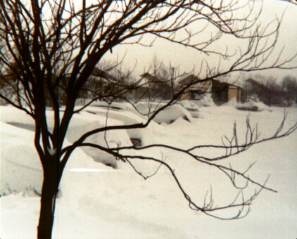